Software: Spectral Image Exploitation – FLAASH®
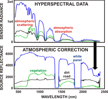
With the Air Force Research Laboratory, NASA, and other US Government agencies SSI has developed a state-of-the-art, first-principles atmospheric ‘correction’ algorithm called FLAASH.
Spectral imagery of the Earth’s surface from airborne or space platforms can be used to fullest advantage only when the effects of the atmosphere (e.g., from aerosol, water vapor, etc.) have been removed (‘corrected’) and the data are reduced to units of reflectance.
FLAASH handles data from virtually all visible-NIR-SWIR hyperspectral and multispectral sensors, supports off-nadir as well as nadir viewing, and incorporates algorithms for water vapor and aerosol retrieval and adjacency effect correction.
FLAASH-IR is closely related thermal atmospheric correction software that operates on long-wave infrared (LWIR) hyperspectral imagery.
FLAASH performs its radiation transport calculations with an embedded MODTRAN®, the latest and most accurate version of SSI’s industry-standard atmospheric radiance and transmission model.
FLAASH is commercially available within the Atmospheric Correction Module (ACM) for ENVI, the popular and powerful image visualization and processing software by Exelis Visual Information Solutions. FLAASH is also available as a stand-alone C++ module suitable for embedding in batch data processing systems.
- To purchase the ENVI Atmospheric Correction Module (ACM), please visit the Harris Geospatial Solutions website. For licensing the ENVI ACM by the month, please visit the CloudEO Store.
- To purchase the stand-alone FLAASH C++ module,
 .
.

