Technology
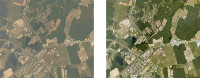
FLAASH (Fast Line-of-sight Atmospheric Analysis of Spectral Hypercubes) is a software tool that corrects visible and near-IR spectral imagery for the effects of the atmosphere using a first principles, physics-based approach. The result is a spectral reflectance image that can be further analyzed for surface classification, material detection and characterization, and other applications. FLAASH was developed collaboratively by Spectral Sciences, Inc. and AFRL, with additional support from NIMA, NASA, and the SITAC. FLAASH is based on radiation transport modeling using the industry-standard MODTRAN code, also developed by the Spectral Sciences/AFRL team. Under Phases 2 and Phase 3 of an AFRL SBIR program, Spectral Sciences, Inc. and Research Systems, Inc. developed a commercial version of FLAASH as a plug-in to the popular ENVI image processing software package. ENVI FLAASH, currently available from Exelis Visual Information Solutions, has enjoyed widespread use in the hyperspectral community since its introduction in December 2001.
Applications
FLAASH supports a wide variety of existing and planned hyperspectral and multispectral sensors, including manned and unmanned aircraft and space-based systems with vertical (nadir) as well as slant path viewing geometries. The accurate atmospheric correction provided by FLAASH maximizes the information that can be extracted from spectral imagery. Enhanced correction accuracy results from a combination of unique features, including the incorporation of unique, pixel-by-pixel MODTRAN solutions, correction for the adjacency effect (spatial blending due to scattering), accurate retrieval of aerosol optical depth, and application of an advanced spectral “polishing” algorithm. In addition, the user-friendly integration of FLAASH with ENVI enables it to be used by non-expert analysts with minimal training.
Private sector use of FLAASH extends to all applications of spectral imagery, including land use, geology, agriculture, and monitoring of the earth’s surface, atmospheric and underwater environments. Commercial profitability has been demonstrated for mineral prospecting and precision agriculture applications. The FLAASH physics-based approach provides an accurate atmospheric correction without requiring the presence of known reflectance materials (“pseudo-invariant objects”) in the scene. This makes it particularly valuable for applications such as agriculture and land use that involve covering large geographic areas.